Our mission is to help computational modelers develop, document, and share their computational models in accordance with community standards and good open science and software engineering practices. Model authors can publish their model source code in the Computational Model Library with narrative documentation as well as metadata that supports open science and emerging norms that facilitate software citation, computational reproducibility / frictionless reuse, and interoperability. Model authors can also request private peer review of their computational models. Models that pass peer review receive a DOI once published.
All users of models published in the library must cite model authors when they use and benefit from their code.
Please check out our model publishing tutorial and feel free to contact us if you have any questions or concerns about publishing your model(s) in the Computational Model Library.
Displaying 10 of 1210 results for "Ian M Hamilton" clear search
Segregation and Opinion Polarization
Thomas Feliciani Andreas Flache Jochem Tolsma | Published Wednesday, April 13, 2016This is a tool to explore the effects of groups´ spatial segregation on the emergence of opinion polarization. It embeds two opinion formation models: a model of negative (and positive) social influence and a model of persuasive argument exchange.
Urban Dynamics
Hideyuki Nagai | Published Monday, November 11, 2019This is an urban dynamics ABM of abstraction of a city and residents’ activities there.
It allows you to evaluate the effects of urban policies, such as an introduction of an open facility for residents with pedestrian-friendly accommodations, promotion of bicycle use, and control of private automobile use in an urban central area, in controlling urban sprawl.
Mobility, Ethnicity, and Language-Based Immigrant Settlement Model - MELBIS
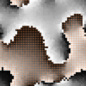
Liliana Perez Jonathan Gaudreau Suzana Dragicevic Taylor Anderson Aaron Leung | Published Monday, June 14, 2021 | Last modified Monday, June 14, 2021MELBIS-V1 is a spatially explicit agent-based model that allows the geospatial simulation of the decision-making process of newcomers arriving in the bilingual cities and boroughs of the island of Montreal, Quebec in CANADA, and the resulting urban segregation spatial patterns. The model was implemented in NetLogo, using geospatial raster datasets of 120m spatial resolution.
MELBIS-V2 enhances MELBIS-V1 to implement and simulate the decision-making processes of incoming immigrants, and to analyze the resulting spatial patterns of segregation as immigrants arrive and settle in various cities in Canada. The arrival and segregation of immigrants is modeled with MELBIS-V2 and compared for three major Canadian immigration gateways, including the City of Toronto, Metro Vancouver, and the City of Calgary.
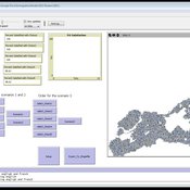
Netlogo model ` Effect of Network Homophily and Partisanship on Social Media to “Oil Spill” Polarizations’
takuya nagura | Published Saturday, September 13, 2025This model was utilized for the simulation in the paper titled Effect of Network Homophily and Partisanship on Social Media to “Oil Spill” Polarizations. It allows you to examine whether oil spill polarization occurs through people’s communication under various conditions.
・Choose the network construction conditions you’d like to examine from the “rewire-style” chooser box.
・Select the desired strength of partisanship from the “partisanlevel” chooser box. You can also set the strength manually in the code tab.
・You can set the number of dynamic topics using the “number-of-topics” slider.
・Use the “divers-of-opinion” slider to set the number of preference types for each dynamic topic.
…
The Agent-Based Model of the Closed Market( similar to Stock Market) with One Commodity and with careful and risky mechanisms
Mark Voronovitsky | Published Sunday, March 15, 2015 | Last modified Sunday, March 22, 2015The model of market of one commodity , in which there are in each moment of time the same quantity and the same quantity of money was formulated and researched in this text. We also study this system as a game of automata.
Introducing two extensions of Schelling's segregation model
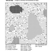
Andreas Flache Carlos A. de Matos Fernandes | Published Monday, January 25, 2021Schelling famously proposed an extremely simple but highly illustrative social mechanism to understand how strong ethnic segregation could arise in a world where individuals do not necessarily want it. Schelling’s simple computational model is the starting point for our extensions in which we build upon Wilensky’s original NetLogo implementation of this model. Our two NetLogo models can be best studied while reading our chapter “Agent-based Computational Models” (Flache and de Matos Fernandes, 2021). In the chapter, we propose 10 best practices to elucidate how agent-based models are a unique method for providing and analyzing formally precise, and empirically plausible mechanistic explanations of puzzling social phenomena, such as segregation, in the social world. Our chapter addresses in particular analytical sociologists who are new to ABMs.
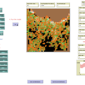
In the first model (SegregationExtended), we build on Wilensky’s implementation of Schelling’s model which is available in NetLogo library (Wilensky, 1997). We considerably extend this model, allowing in particular to include larger neighborhoods and a population with four groups roughly resembling the ethnic composition of a contemporary large U.S. city. Further features added concern the possibility to include random noise, and the addition of a number of new outcome measures tuned to highlight macro-level implications of the segregation dynamics for different groups in the agent society.
In SegregationDiscreteChoice, we further modify the model incorporating in particular three new features: 1) heterogeneous preferences roughly based on empirical research categorizing agents into low, medium, and highly tolerant within each of the ethnic subgroups of the population, 2) we drop global thresholds (%-similar-wanted) and introduce instead a continuous individual-level single-peaked preference function for agents’ ideal neighborhood composition, and 3) we use a discrete choice model according to which agents probabilistically decide whether to move to a vacant spot or stay in the current spot by comparing the attractiveness of both locations based on the individual preference functions.
…
Peer reviewed Behavior changes through influence
Daria Soboleva | Published Friday, August 30, 2024The model is designed to simulate the behavior and decision-making processes of individuals (agents) in a social network. It aims to represent the changes in individual probability to take any action based on changes in attributes. The action is anything that can be reasonably influenced by the three influencing methods implemented in this model: peer pressure, social media, and state campaigns, and for which the user has a decision-making model. The model is implemented in the multi-agent programmable environment NetLogo 6.3.0.
Prisoner's Dilemma Game on Complex Networks with Agents' Adaptive Expectations
Bo Xianyu | Published Wednesday, November 16, 2011 | Last modified Saturday, April 27, 2013This model studies the effect of the agents’ adaptive expectation on cooperation frequency in the prisoner’s dilemma game in complex networks from an agent based approach. The model is implemented in Repast simphony 1.2.
Peer reviewed MOOvPOPsurveillance
Matthew Gompper Aniruddha Belsare Joshua J Millspaugh | Published Tuesday, April 04, 2017 | Last modified Tuesday, May 12, 2020MOOvPOPsurveillance was developed as a tool for wildlife agencies to guide collection and analysis of disease surveillance data that relies on non-probabilistic methods like harvest-based sampling.
SugarscapeCW
Christopher Watts | Published Saturday, August 01, 2015 | Last modified Wednesday, April 12, 2023A replication in Netlogo 5.2 of the classic model, Sugarscape (Epstein & Axtell, 1996).
Displaying 10 of 1210 results for "Ian M Hamilton" clear search