Our mission is to help computational modelers develop, document, and share their computational models in accordance with community standards and good open science and software engineering practices. Model authors can publish their model source code in the Computational Model Library with narrative documentation as well as metadata that supports open science and emerging norms that facilitate software citation, computational reproducibility / frictionless reuse, and interoperability. Model authors can also request private peer review of their computational models. Models that pass peer review receive a DOI once published.
All users of models published in the library must cite model authors when they use and benefit from their code.
Please check out our model publishing tutorial and feel free to contact us if you have any questions or concerns about publishing your model(s) in the Computational Model Library.
Displaying 10 of 350 results for "Chelsea E Hunter" clear search
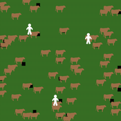
MASTOC-LLM (Multi-Agent System Tragedy of the Commons - Large Language Models)
Thomas Tuoti | Published Monday, May 18, 2026 | Last modified Tuesday, May 19, 2026MASTOC-LLM extends the classic Multi-Agent System Tragedy of the Commons (MASTOC) model by replacing hard-coded behavioral rules with autonomous decision-making powered by large language models (LLMs). Three heterogeneous agents manage herds of cows on a shared grassland commons. Each tick, an agent receives a structured prompt describing current resource levels, its own herd size, peer behavior, and — optionally — a rolling memory of recent rounds and messages from neighboring agents. The LLM returns a stocking decision (add, remove, or hold cows) together with a natural-language rationale and, when communication is enabled, a short message to broadcast to peers.
The model is designed to test whether LLM agents spontaneously develop Ostrom-style common-pool resource governance (mutual monitoring, graduated sanctions, graduated rule revision) or instead fall into identifiable failure modes. Preliminary experiments with Claude Haiku 4.5, GPT-5.4-mini, and DeepSeek R1:32b have revealed four recurring collapse patterns — Cooperative Paralysis, Defection Cascade, Overshoot-Panic, and Hybrid Architecture Failure — whose onset timing is sensitive to memory length, inter-agent communication, and the post-training alignment approach of the underlying model.
MASTOC-LLM is intended as a laboratory for generative agent-based modelling (GABM) methodology: it provides a clean, well-understood commons baseline against which LLM behavioral hypotheses can be systematically tested and compared across models, parameter sweeps, and alignment regimes.
Peer reviewed Simulating the Economic Impact of Boko Haram on a Cameroonian Floodplain
Mark Moritz Nathaniel Henry Sarah Laborde | Published Saturday, October 22, 2016 | Last modified Wednesday, June 07, 2017This model examines the potential impact of market collapse on the economy and demography of fishing households in the Logone Floodplain, Cameroon.
Social identity approach in a data-driven Axelrod model
alejandrodinkelberg | Published Thursday, July 28, 2022Simulations based on the Axelrod model and extensions to inspect the volatility of the features over time (AXELROD MODEL & Agreement threshold & two model variations based on the Social identity approach)
The Axelrod model is used to predict the number of changes per feature in comparison to the datasets and is used to compare different model variations and their performance.
Input: Real data
…
Competitive Arousal Agent Based Model
Zoé Chollet | Published Friday, May 13, 2022What is it?
This model demonstrates a very simple bidding market where buyers try to acquire a desired item at the best price in a competitive environment
…
Peer reviewed Flibs'NLogo - An elementary form of evolutionary cognition
Cosimo Leuci | Published Thursday, January 30, 2020 | Last modified Monday, June 15, 2026Flibs’NLogo is an agent-based simulation implemented in NetLogo that models the evolution of perfect predictors through a genetic algorithm. The agents, called flibs (finite living blobs), are finite‑state automata whose behaviour is encoded in circular chromosomes. They inhabit a “primordial computer soup” and are tasked with anticipating a user‑defined periodic binary sequence. Each generation consists of 100 evaluation cycles, during which a flib’s fitness is incremented each time its output correctly matches the next environmental signal.
Reproduction follows an elitist scheme: a donor (current fittest individual) replaces a randomly chosen recipient either by cloning (complete genome substitution) or by bacterial‑like conjugation (unidirectional horizontal transfer of a random chromosome segment). A stochastic mutagenesis operator introduces point mutations in genes, while the reproductive strategy gene can also switch under a mixed-reproduction regime. Population dynamics are monitored via genomic diversity indices (Shannon‑Wiener, Simpson), a phenotypic simpleness metric that distinguishes the low number of states actually used from the genomic potential.
The model serves as a digital evolutionary laboratory for exploring the interplay among bounded rationality, collective adaptation, and the emergence of anticipatory behaviour. By linking evolutionary computation with cognitive concepts, Flibs’NLogo investigates fundamental transitions from reactive to predictive systems and allows for testing whether populations evolve toward minimal necessary complexity or exhibit an intrinsic drift toward structural elaboration.
MTC_Model_Pilditch&Madsen
Toby Pilditch | Published Friday, October 09, 2020Micro-targeted vs stochastic political campaigning agent-based model simulation. Written by Toby D. Pilditch (University of Oxford, University College London), in collaboration with Jens K. Madsen (University of Oxford, London School of Economics)
The purpose of the model is to explore the various impacts on voting intention among a population sample, when both stochastic (traditional) and Micto-targeted campaigns (MTCs) are in play. There are several stages of the model: initialization (setup), campaigning (active running protocols) and vote-casting (end of simulation). The campaigning stage consists of update cycles in which “voters” are targeted and “persuaded” - updating their beliefs in the campaign candidate / policies.
Modeling Civilian Loyalty and Territorial Control in Irregular Warfare: An Agent-Based Model
Andrea Molle | Published Thursday, April 09, 2026An agent-based model of irregular warfare in which civilians adapt their alignment in response to local violence, security presence, and territorial control. The simulation explores how decentralized interactions generate spatial patterns of loyalty, conflict dynamics, and stabilization.
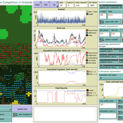
Peer reviewed LUCID: Land Use Competition In Drylands
Birgit Müller Gunnar Dressler Lance Robinson | Published Wednesday, April 12, 2023The Land Use Competition in Drylands (LUCID) model is a stylized agent-based model of a smallholder farming system. Its main purpose is to illustrate how competition between pastoralism and crop cultivation can affect livelihoods of households, specifically their food security. In particular, the model analyzes whether the expansion of crop cultivation may contribute to a vicious circle where an increase in cultivated area leads to higher grazing pressure on the remaining pastureland, which in turn may cause forage shortages and livestock loss for households which are then forced to further expand their cultivated area in order to increase their food security. The model does not attempt to replicate a particular case study but to generate a general understanding of mechanisms and drivers of such vicious circles and to identify possible scenarios under which such circles may be prevented.
The model is inspired by observations of the Borana land use system in Southern Ethiopia. The climatic and ecological conditions of the Borana zone favor pastoralism, and traditionally livelihoods have been based mainly on livestock keeping. Recent years, however, have seen an advancement of crop cultivation as a coping strategy, e.g., to compensate the loss of livestock, even though crop yields are low on average and successful harvests are infrequent.
In the model, it is possible to evaluate patterns of individual (single household) as well as overall (across all households) consumption and food security, depending on a range of ecological, climatic and management parameters.
Agent-based model of WiFi tracking system in urban environment
Christopher Thron Khoi Tran | Published Friday, April 21, 2017This code simulates the WiFi user tracking system described in: Thron et al., “Design and Simulation of Sensor Networks for Tracking Wifi Users in Outdoor Urban Environments”. Testbenches used to create the figures in the paper are included.
Hybrid Climate Assessment Model (HCAM)
Peer-Olaf Siebers | Published Friday, February 15, 2019Our Hybrid Climate Assessment Model (HCAM) aims to simulate the behaviours of individuals under the influence of climate change and external policy makings. In our proposed solution we use System Dynamics (SD) modelling to represent the physical and economic environments. Agent-Based (AB) modelling is used to represent collections of individuals that can interact with other collections of individuals and the environment. In turn, individual agents are endowed with an internal SD model to track their psychological state used for decision making. In this paper we address the feasibility of such a scalable hybrid approach as a proof-of-concept. This novel approach allows us to reuse existing rigid, but well-established Integrated Assessment Models (IAMs), and adds more flexibility by replacing aggregate stocks with a community of vibrant interacting entities.
Our illustrative example takes the settings of the U.S., a country that contributes to the majority of the global carbon footprints and that is the largest economic power in the world. The model considers the carbon emission dynamics of individual states and its relevant economic impacts on the nation over time.
Please note that the focus of the model is on a methodological advance rather than on applying it for predictive purposes! More details about the HCAM are provided in the forthcoming JASSS paper “An Innovative Approach to Multi-Method Integrated Assessment Modelling of Global Climate Change”, which is available upon request from the authors (contact peer-olaf.siebers@nottingham.ac.uk).
Displaying 10 of 350 results for "Chelsea E Hunter" clear search