Our mission is to help computational modelers develop, document, and share their computational models in accordance with community standards and good open science and software engineering practices. Model authors can publish their model source code in the Computational Model Library with narrative documentation as well as metadata that supports open science and emerging norms that facilitate software citation, computational reproducibility / frictionless reuse, and interoperability. Model authors can also request private peer review of their computational models. Models that pass peer review receive a DOI once published.
All users of models published in the library must cite model authors when they use and benefit from their code.
Please check out our model publishing tutorial and feel free to contact us if you have any questions or concerns about publishing your model(s) in the Computational Model Library.
Displaying 10 of 168 results for "L S Premo" clear search
SimAdapt
François Rebaudo | Published Wednesday, August 29, 2012 | Last modified Monday, October 13, 2014SimAdapt: An individual-based genetic model for simulating landscape management impacts on populations
The Groundwater Commons Game
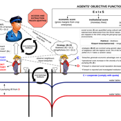
Juan Castilla-Rho Rodrigo Rojas | Published Thursday, May 11, 2017 | Last modified Saturday, September 16, 2017The Groundwater Commons Game synthesises and extends existing work on human cooperation and collective action, to elucidate possible determinants and pathways to regulatory compliance in groundwater systems globally.
IUCM - The Integrated Urban Complexity Model
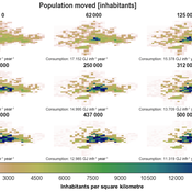
Roger Cremades Philipp S. Sommer | Published Thursday, December 14, 2023We present the Integrated Urban Complexity model (IUCm 1.0) that computes “climate-smart urban forms”, which are able to cut emissions related to energy consumption from urban mobility in half. Furthermore, we show the complex features that go beyond the normal debates about urban sprawl vs. compactness. Our results show how to reinforce fractal hierarchies and population density clusters within climate risk constraints to significantly decrease the energy consumption of urban mobility. The new model that we present aims to produce new advice about how cities can combat climate change. From a technical angle, this model is a geographical automaton, conceptually interfacing between cellular automata and spatial explicit optimisation to achieve normative sustainability goals related to low energy. See a complete user guide at https://iucm.readthedocs.io/en/latest/ .
Agent modeling (ABM) as a tool to improve the mobility of “avoidant” birds in an ecological corridor in the localities of Chapinero, Teusaquillo, Barrios Unidos and Engativá of Bogotá city [Scenario 2]
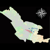
Paula Alejandra Meza | Published Thursday, June 25, 2026Considering that two of the three avoider species could not reach the target area in the inittial scenario, five alternative corridor scenarios were created. In all cases, we generated a greater amount of cover area under ‘Urban forest’, including elements such as scattered trees, woody plants, wooded areas, and rows of trees. This covered type was selected since all three species use it as a regular habitat. That is the second sceneario where those ecological parks and other areas inside the capital city were boostered into “urban forest patches” or buffer points, with the idea of improving the survive of the three bird species and their movement. However one of the most restrictive specie was still having movement and survival issues.
Irrigation Equity and Efficiency
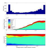
Andrew Bell | Published Tuesday, August 30, 2016The purpose of this model is to examine equity and efficiency in crop production across a system of irrigated farms, as a function of maintenance costs, assessed water fees, and the capacity of farmers to trade water rights among themselves.
3D Urban Traffic Simulator (ABM) in Unity
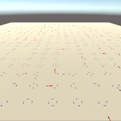
Daniel Birks Sedar Olmez Obi Thompson Sargoni Alison Heppenstall Annabel Whipp Ed Manley | Published Friday, January 22, 2021 | Last modified Monday, March 22, 2021The Urban Traffic Simulator is an agent-based model developed in the Unity platform. The model allows the user to simulate several autonomous vehicles (AVs) and tune granular parameters such as vehicle downforce, adherence to speed limits, top speed in mph and mass. The model allows researchers to tune these parameters, run the simulator for a given period and export data from the model for analysis (an example is provided in Jupyter Notebook).
The data the model is currently able to output are the following:
…
Universal Darwinism in Dutch Greenhouses
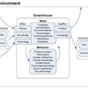
Julia Kasmire | Published Wednesday, May 09, 2012 | Last modified Saturday, April 27, 2013An ABM, derived from a case study and a series of surveys with greenhouse growers in the Westland, Netherlands. Experiments using this model showshow that the greenhouse horticulture industry displays diversity, adaptive complexity and an uneven distribution, which all suggest that the industry is an evolving system.
Peer reviewed CHIME ABM of Hurricane Evacuation
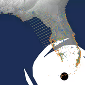
C Michael Barton Sean Bergin Joshua Watts Joshua Alland Rebecca Morss | Published Monday, October 18, 2021 | Last modified Tuesday, January 04, 2022The Communicating Hazard Information in the Modern Environment (CHIME) agent-based model (ABM) is a Netlogo program that facilitates the analysis of information flow and protective decisions across space and time during hazardous weather events. CHIME ABM provides a platform for testing hypotheses about collective human responses to weather forecasts and information flow, using empirical data from historical hurricanes. The model uses real world geographical and hurricane data to set the boundaries of the simulation, and it uses historical hurricane forecast information from the National Hurricane Center to initiate forecast information flow to citizen agents in the model.
LogoClim: WorldClim in NetLogo
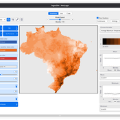
Daniel Vartanian Leandro Garcia Aline Martins de Carvalho Aline | Published Thursday, July 03, 2025 | Last modified Monday, July 13, 2026LogoClim is a NetLogo model designed to be integrated into other simulations through the LevelSpace extension (Hjorth et al., 2020), providing high resolution climate data from sources validated and used by the Intergovernmental Panel on Climate Change (IPCC).
The model simplifies and standardizes the integration of climate data into NetLogo, allowing researchers to focus their efforts on the model itself with the assurance of using reliable and widely recognized data. Although its main use is as a component of larger simulations, LogoClim also has its own graphical interface for monitoring and checking the datasets.
The climate data comes from the WorldClim 2.1 project (Fick & Hijmans, 2017), for which LogoClim works as an interface to NetLogo. The model supports all three WorldClim data series: (1) Historical Climate Data (1970 to 2000), with 12 monthly points for minimum, mean, and maximum temperature, precipitation, solar radiation, wind speed, vapor pressure, elevation, and bioclimatic variables; (2) Historical Monthly Weather Data (1951 to 2024), based on downscaling of CRU-TS-4.09, developed by the Climatic Research Unit at the University of East Anglia (Harris et al., 2020), with minimum and maximum temperature and total precipitation; and (3) Future Climate Data, based on downscaling climate projections derived from global climate models of the Coupled Model Intercomparison Project Phase 6 (CMIP6) (Eyring et al., 2016) for four future periods (2021 to 2040, 2041 to 2060, 2061 to 2080, and 2081 to 2100) and four scenarios based on the Shared Socioeconomic Pathways (SSPs 126, 245, 370, and 585), covering minimum and maximum temperature, total precipitation, and bioclimatic variables. All series are available at multiple spatial resolutions, from 10 minutes (about 340 km² at the equator) to 30 seconds (about 1 km² at the equator).
…
Peer reviewed The Effect of Spatial Clustering on Stone Raw Material Procurement
Marco Janssen Simen Oestmo Curtis W Marean | Published Friday, April 21, 2017This model allows for the investigation of the effect spatial clustering of raw material sources has on the outcome of the neutral model of stone raw material procurement by Brantingham (2003).
Displaying 10 of 168 results for "L S Premo" clear search